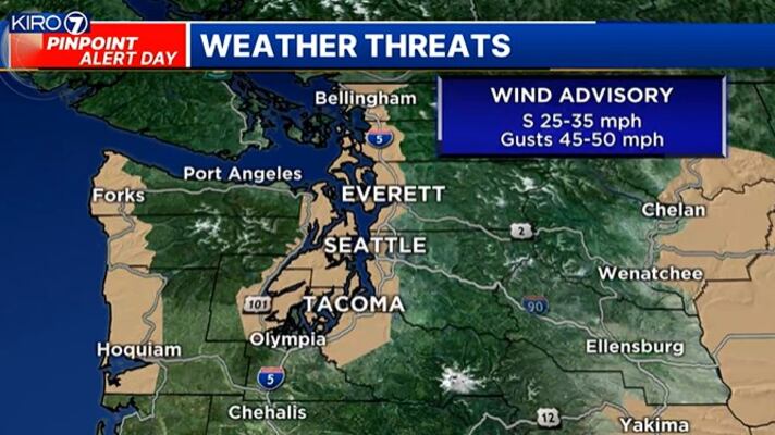
SEATTLE — Another atmospheric river is moving over the area Wednesday with widespread rain that will become increasingly heavy. It’s already breezy to windy and will become stronger later today. Plus, we have a lot of snow falling in the mountains now with plenty more on the way.
Let’s start with the rain. Rain will increase in intensity and coverage this morning, becoming heaviest this afternoon. 1 to 3 inches of rain will fall into Thursday morning, with highest totals at the coast and in the mountains. Inland, it will be 1 to 2 inches range, again becoming heaviest this afternoon.
It’s already windy right now but the wind will pick up. Our Wind Advisory lasts until late this afternoon and early evening. Sustained wind will be around 25 to 35 mph with gusts around 40 to 45 mph or even at times, 50 mph. Gusts of 50 mph are most likely at the coast and in the mountains, but some areas north and closer to the water could hit 50 mph at times.
Happy Wednesday! It will be wet and windy today with snow in the mountains. My goal is to get you ready for when you'll have the heaviest rain, where and when we'll have the strongest wind and talk windy and very snow mountains. #NickKnows #wawx pic.twitter.com/w5x9zq3SJ5
— Nick Allard (@NickAllardKIRO7) February 28, 2024
In the mountains, we have a Winter Storm Warning for around 2 to 4 feet of snow. The passes will be in the 1 to 2 foot range, with the lowest totals around Snoqualmie. The snow level will be around 4,000 feet today, falling to around 3,000 feet tonight and then much lower overnight into Thursday. That means Snoqualmie Pass will see rain for a lot of the day turning to snow tonight.
Good morning!
— Snoqualmie Pass (@SnoqualmiePass) February 28, 2024
Thank you @wspd2pio @wspd6pio for doing chain enforcement. I-90/Snoqualmie received 10 inches of snow in 24 hours & we will remain in a very active weather pattern through the weekend. https://t.co/ItKmjWJRyj pic.twitter.com/QqJKTQV1dg
Wind gusts will be in the 50 mph range as well, which means the potential for blowing snow. There is an Avalanche Warning for our mountains today because of the heavy snow, wind and rain. It is NOT a good day to go off-trail or really even hit the slopes.
The back edge of this system, or the cold front, will move through late tonight and early Thursday morning. We’ll have a slow tapering of the wind and the end to the heavy rain.
Looking ahead
Thursday looks like a scattered shower kind of day with the chance for isolated thunderstorms. This will usher in colder air and highs back in the 40s on Friday with showers.
By Friday night and again Saturday night, snow levels will be low enough for some rain/snow mix in some lowland areas. Impacts look spotty and minor right now, but we’ll be monitoring.
It will be a little drier on Sunday but then more rain and mountain snow to start next week.
©2024 Cox Media Group


